
How We Can Help You
Campbell Scientific designs and builds standard Automated Local Evaluation in Real Time (ALERT), ALERT2™, hybrid ALERT, and customised flood-warning systems. This includes a turn-key transmitter packaged in a traditional Event Reporting Radio Telemetry System (ERRTS) style canister for standpipe installation. The data loggers at the heart of our systems have been proven over decades in the harshest, most remote conditions. You can add our systems to an existing network of stations, or we can customise a system for your unique application.
For customers currently using legacy ALERT systems, Campbell Scientific can provide assistance in the transition to ALERT2™.
Learn moreTo see how our systems meet your application needs, review our case studies »


Instrumentation
We offer a variety of products that can be used to create systems for Flood Warning Systems (ALERT/ALERT2). Many of the major components used to create these systems are listed below. Please let us know if we can help you configure a system.
More Details about Our Flood Warning Systems (ALERT/ALERT2) Systems
ALERT System
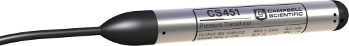
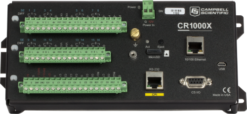
Our ALERT systems match all standard ALERT protocols, including ALERT2. Our data loggers, proven in thousands of applications worldwide, provide multiple types of inputs (pulse, analog, SDI-12, and others), which allow you to use almost any type of water-level sensor (including pressure transducers, shaft encoders, bubblers, and ultrasonic distance sensors). The onboard algorithms are able to calculate hourly and daily minimums, maximums, averages, totals, flow, or any other statistical value. These values can be stored onboard the system, providing you with a backup of the data. A solar panel provides continuous charge to the battery for your extended, unattended monitoring needs.
If you need additional sensors to measure soil moisture, water quality, or meteorological conditions, it is easy to integrate them. We can upgrade older systems—even those from other manufacturers—with the latest data logger and transmitter, often allowing you to use the same sensors and standpipe or enclosure.
ALERT2 Systems
The added performance of ALERT2 systems makes them a logical choice for new systems and for upgrading existing networks. The main advantage is the ability to have larger networks and greatly reduced data loss. When you upgrade an older ALERT network to ALERT2, you don't have to update the complete system all at once. Rather, you can complete the upgrade in phases to ease the cost and labor burdens. All the other functions and features of the original ALERT systems are still available with ALERT2.
Campbell Scientific equipment has been used for some of the largest and most widely used ALERT2 networks in the country. For an example of the performance of these systems, read the "Texas: Transitioning to ALERT2" case study.
Note: ALERT2 is a trademark of the National Hydrologic Warning Council.
Hybrid ALERT Systems
Our hybrid systems consist of an ALERT system integrated with additional sensors and communications peripherals. One or two radio frequencies can be used, depending on your needs. With a single frequency, two-way communications are avoided during storm events to allow more bandwidth for one-way ALERT communications. You may, however, choose to use two frequencies: one for ALERT and the other for a fully functional, two-way communications network. This provides the following inherent advantages:
- Retries of missed packets
- Diagnostics
- Clock synchronization
- Re-programming from the base station
- Historical data collection (no holes in the data)
- Interactive control capability
- Voice modem call-out of alarms
If you are able to measure additional parameters at your ALERT site, or to integrate ALERT capabilities with another type of measurement site, it may be easier for you to collaborate with another organization. Collaboration may help keep your costs down.
Customized Flood Warning Network Using LoggerNet Software
A flood warning network that uses LoggerNet software takes advantage of two-way RF communications and the latest in network management software. LoggerNet is a client/server software program used for managing large networks of monitoring stations. A LoggerNet-based system is a viable solution for flood warning applications for two reasons:
- The speed at which LoggerNet can poll multiple RF stations
- The speed and versatility with which LoggerNet can make the data available to multiple interested parties
When a "send data" command is broadcast to a group of remote stations, the stations transmit predefined data to the LoggerNet server in their own time window. Transmission windows can be as short as 100 ms, allowing multiple sites to be polled per second. As the data is collected, LoggerNet clients access it from LANs or via the Internet, making the data available to multiple users or agencies in near real time.
Other Resources and Options
To meet your application's specific needs, you can combine other resources and communications options with flood warning systems. It is common for local governments to combine resources to obtain the best possible system. In other situations, federal agencies are involved, which increases system coverage and robustness, and even helps with the budget. For example, GOES satellite transmitters can be added to stations to provide automated data archival through the National Weather Service (NOAA/NESDIS) and the U.S. Geological Survey (USGS). Multiple-purpose data-collection systems bring to bear the resources and expertise of environmental data experts.
Case Studies
The Panama Canal was using an outdated water-level system until the Panama Canal Authorities (ACP)......read more
In February of 2015, Campbell Scientific was awarded a bid to supply the Harris County......read more
Flooding is the number one natural cause of fatalities worldwide and was responsible for 6.8......read more
ALERT2 is a modern communication protocol that improves upon 40 years of tradition within the......read more
Inundation from flood waters is an annual occurrence for many living in Far North Queensland.......read more
The Charlotte-Mecklenburg Flood Information and Notification System (FINS) consists of over 125 gaging stations spread......read more
The National Weather Service (NWS) operates a network of automated flood-warning stations around Mount St.......read more
Networks using the ALERT protocol are designed to give immediate access to data that indicates......read more
Documents
Technical Papers
Miscellaneous
Related Product Categories
Articles and Press Releases
Press Releases
Privacy Policy Update
We've updated our privacy policy. Learn More
Customise a System
In addition to our standard systems available, many of the systems we provide are customised. Tell us what you need, and we’ll help you configure a system that meets your exact needs.